Seep Zone
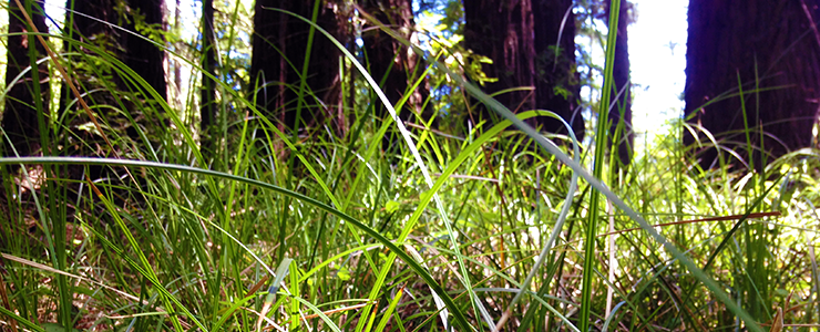
Water-loving slough sedge growing in the the seep zone on UCSC Campus Natural Reserve
Seep Zone (65 acres)
General Description: Stretching between West Road and Fuel Break Road/Chinquapin Road above College 9/10 is a steep, gullied area of damp redwood forest, mixed evergreen forest, and a small grassland known as Crown Meadow. Known as the seep zone, this area of the reserve contains a number of springs and seeps which originate in upper west campus (Stanley 1983). The seep zone and adjacent meadow receive extensive use by a number of field classes, as well as by recreating students and members of the general public. This portion of the reserve exemplifies one of the campus’s greatest values, the juxtaposition of a number of habitat types—in this case, redwood forest, riparian areas, mixed evergreen forest, chaparral, and grassland—in a small area. The seeps and springs of the seep zone create riparian habitats; the least extensive habitat type on campus, riparian areas cover less than one percent of the campus lands (Twiss 1966). Fortunately, the reserve contains most of the campus’s riparian habitats, including Moore Creek, Cave Gulch, the seep zone, and the headwaters of Jordan Gulch. This section of the reserve also exemplifies the challenges of managing a reserve situated in a popular recreation destintation.
Geology: Santa Margarita sandstone covers the underlying schist in an east-west band along the upper edge of the seep zone. Schist also underlies the remainder of this section, but the sandstone has been removed through erosion (Stanley 1982). As mentioned above, water that feeds the springs and seeps of this zone originates in the level section covered by Santa Margarita sandstone just north of the seep zone. According to Stanley (1983), the sandstone forms an aquifer that stores winter rains; water then flows through fractures in the underlying schist and reappears as springs in the seep zone.
Campus soil types found in the seep zone include an unnamed sandy loam, Felton loam, and Felton loam and Felton rocky loam on the hillside and in the steep gully of Upper Jordan Gulch’s west fork. Felton loam and Felton rocky loam also occur on Upper Jordan Gulch’s east fork, along with an unnamed sandy loam. The area to the north and east of the North Remote parking lot is a mosaic of Hugo rocky loam, Holland loam, Felton loam, and unnamed gravelly sandy loam (Arkley 1963). Hugo rocky loam is subject to severe erosion when cleared, as can be seen on the steep trail just north of the drainage/culvert under West Road just past the parking lot.
 Plants: Within the seep zone is the only extensive example of wetlands redwood forest on campus (Weiner and Norris 1983). A variety of fern populations grows here, as does a well-developed understory of such species as redwood sorrel, Pacific star-flower (Trientalis latifolia), and redwood violet (Viola sempervirens), and a beautiful azalea stand. Brown and Norris (1985) reference several species that were found around the forest springs—three species at their southern range limit in Santa Cruz: western raspberry (Rubus leucodermis), Torrey’s trefoil (Lotus oblongifolius var. nevadensis) and ample-leaved sedge (Carex amplifolia) (Keeler-Wolf and Keeler-Wolf 1974); and three other species rare in the Santa Cruz Mountains: floriferous monkey flower (Mimulus floribundus), keeled club-rush (Isolepis carinata), and Olney’s hairy sedge (Carex gynodynama) (Stone 1983). Of these six species, only Olney’s hairy sedge has been observed in recent years (A. Jones, pers. obs.). Also significant is the oracle oak (Quercus morehus), a form intermediate between coast live oak and California black oak (Q. kelloggii). According to Stone (1983), the oracle oak is of scientific interest because black oak is confined to the Santa Cruz Mountains’ higher ridges and does not occur on or near the campus. In reference to this phenomenon, Stone (1983) writes,
"Therefore the occasional occurrence of oracle oak in areas approaching the coast, as at Bonny Doon (Thomas 1961) and on the north coast (Buck 1982) as well as on campus, may represent gene pool remnant from a period 10,000 to 6,000 years before present, when the California climate was significantly warmer and drier that it today (Pielou 1979). During this time black oaks may well have occurred this close to the coast."
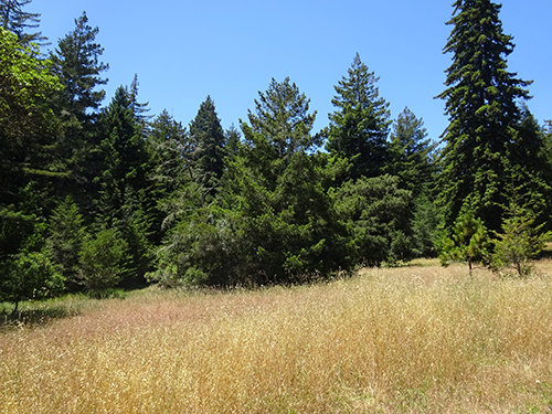
Adjacent to the seep zone, near the intersection of Spring Road and Fuel Break Road, lays a small grassland called the Crown Meadow. One of the ungrazed grasslands on campus, it provides habitat for a large number of plants and insects, formerly including five plant species rare in the Santa Cruz Mountains (Norris 1985). One of these, the grape fern (Sceptridium multifidum ssp. silaifolium) is only known in Santa Cruz County from two sites on campus (LRDP 2005), only one of which was located during a search in 2012 (A. Jones, pers. obs.). The meadow edges, which adjoin forest and chaparral, provide sites to study vegetation succession and valuable animal habitats.
The Seep Zone parcel also includes a section of knobcone pine (Pinus attenuata) forest, which in 2014 was becoming dominated by Douglas-fir and huckleberry in the absence of fire to promote regeneration.
 Animals: Brown and Norris (1985) referenced the seep zone’s importance for invertebrate study, as both a field trip locale and a collecting site. According to Luckenbach (1983), many species of invertebrates, including Tricoptera, Plecopetera, and Odonata, are dependent on the year-round riparian habitats created by springs and seeps. Emeritus biology professors Todd Newberry and John Pearse (K. Norris, pers. comm., 1986) noted the value of the seep zone to their classes, and mentioned the abundance of wingless insects, such as centipedes and millipedes, and micrometazoa, such a tardigrades and rotifers, that are available there for study and collection.
The seep zone is also a valuable site for the study of larger animals. The dense vegetation around the seeps and springs create important habitats for many mammals, such as shrews (Sorex spp.), the California meadow mole (Microtus californicus), and other insectivores. An Environmental Studies 100 in the early 1980s class studied use of springs by larger mammals, and discovered high visitation by foxes, bobcats, and mule deer (Luckenbach 1983).
Management: The UCSC Grounds Department mows fire breaks along the edges of Crown Meadow and removed coyote brush from the southwestern corner of the meadow in summer 2012. The Seep Zone Interpretive Trail is maintained by CNR staff and spur trails are routinely blocked off.
Opportunities for teaching, research, and stewardship: The close proximity to the science complex, along with a well-developed network of fire roads, makes this part of the reserve one of the most heavily used by classes. The Seep Zone Interpretive Trail features 13 interpretive signs that educate hikers along the trail; these signs replaced the numbered posts/interpretive pamphlet in fall 2012. EEB professor Ingrid Parker has several deer exclosure plots in the Seep Zone area that are visited annually by her Plant Ecology class. Other research includes a sword fern citizen science project supported by Save the Redwoods League and EEB professor Jarmila Pittermann. The Seep Zone parcel’s proximity to Crown, Merrill, and Colleges 9 & 10 also results in heavy use from students, who routinely use Crown Meadow and the surrounding redwood forest areas as party sites. Students and Santa Cruz (and beyond) residents also use the dense network of unauthorized trails for mountain biking. Stewardship opportunities include trail maintenance and closures, sign maintenance, invasive species management, trash pick-ups, stick fort and campfire removal, and native plant restoration within Crown Meadow.
“Under-drained Depression”
The under-drained depression lies between North Fuel Break Road and Chinquapin Road, north of the seep zone. Very little of this area remains in the CNR; the land-use designations of much of the under-drained depression area of land contained within 1988 LRDP CNR boundaries was reclassified by the 2005 LRDP as Physical Education, Academic Core, and Protected Landscape (LRDP 2005).
Nevertheless, this area is rather unique. Schist forms the underlying bedrock of the site, with a cover of Santa Margarita sandstone (Stanley 1983). According to Arkley (1983) the plant community found here probably occurs at only a few other sites in the Santa Cruz Mountains. The southern half of the site is classified as live oak-manzanita chaparral, and the northern half as mixed evergreen forest by Stone (1983). Since that classification, it has been reclassified as Chaparral-Forest-Transition and Mixed Evergreen Forest by the URS and Jones and Stokes consulting firms (LRDP 2005). Brown and Norris (1985) noted that many hybrids between coast and Shreve’s oak (at the time identified as interior live oak) occur in the chaparral. Douglas-firs and redwoods are abundant in the mixed evergreen forest (Buck 1983). Riparian species, such as sedges and rushes, occur in the under-drained depressions, and historically western bent grass (Agrostis exarata) and coyote-thistle (Eryngium armatum) were noted. As with the seep zone, the underdrained depression supports a number of springs and watercourses which ultimately feed the seep zone.
